
HORACE, N.D. – The Army Corps of Engineers reported a milestone to reduce the Red River flood risk to more than 235,000 people in the Fargo and Moorhead area on the Minnesota-North Dakota border. The first of two 110,000-pound Tainter gates was installed at a flood-control structure on the Wild Rice River tributary 15 miles upriver from Fargo at Horace, North Dakota. The gates, when both are installed, will divert flood water to a 30-mile channel around Fargo and Moorhead before reconnecting to the Red River downstream.
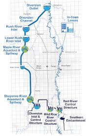
Red River of the North. The 550-mile river, in light blue, flows north from drainages in western Minnesota and eastern North Dakota into Canada. Because the river flows north, the lower reaches thaw last in the spring and dam up and flood southern sections. The dark blue is the Army Corps bypass being built to protect Fargo ad Moorhead.
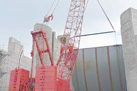
Dropping carefully, very carefully. Crane lowers 55-ton metal gate into place on a flood-control structure designed to protect Fargo and Moorhead from more Red River ravages. Image: Patrick Moes